
PeakVisor - 3D Maps & Peaks Id
In-app purchases

star
1.22K reviews

PEGI 3
info
1L+
Downloads

PEGI 3
Learn more


About this app
PeakVisor will make you a champion of mountain navigation, putting state-of-the-art Peak Identification, 3D Maps, Trails, and outdoor GPS tracking into the palm of your hand. Our app is a one-stop shop for all your mountain adventures: hiking, skiing, climbing, mountain biking, and more. But PeakVisor is more than just another outdoors app; it’s an immersion into a carefully crafted 3D world that will give you an unprecedented understanding of the nuances of a mountain’s terrain.
Here’s a brief orientation on the tools we offer to get oriented in the mountains:
● 3D Maps
As human athletic achievement progresses in the mountains, so does the technology to assist your adventures. With PeakVisor, you unlock the topo maps of the future; our cutting-edge technology with high-precision terrain modeling offers deep insight into the mountain landscape of your choice. With one glance, you be blessed with years of knowledge about an area’s terrain.
● Identify Peaks
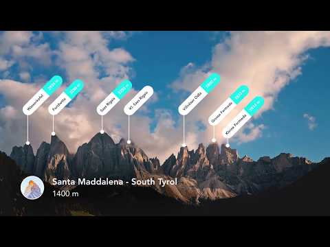
Identify more than a million mountains, hills, buttes, spires, and more from all over the world, with a detailed profile for each of them! Our app shows you altitude, topographic prominence, mountain range, national parks or reserves, as well as photos and additional Wikipedia articles.
● Plan Hiking Routes
A vast network of worldwide hiking trails and walking pathways included in PeakVisor’s 3D Maps will help you compose a hiking route which includes evaluating the distance you can expect to hike as well as a route’s elevation profile and estimated time for completion.
● Skiing
In winter mountain sports, PeakVisor’s topographic 3D Maps allow a visual understanding of the terrain and provide detailed information about mountain lifts, ski resort trails, and backcountry ski touring routes. The app also offers features such as winter mode and a slope steepness overlay to identify avalanche terrain on your route.
● Cable Cars and Mountain Huts are inlaid onto our 3D Maps, complete with schedules. This is especially useful in Europe, where many objectives involve a cable car ride to gain some altitude, lest you want to do some genuinely punishing climbs. And you haven’t experienced the old-world mountain culture until you’ve had a memorable meal and night at a rustic mountain hut in the high country.
● Peak Bagging
The app offers monthly climbing challenges and Peak Bagging competitions to keep the motivation where it needs to be…UP.
● GPS Tracking
Track any outdoor adventures, whether hiking, skiing, mountain biking, etc. Post-adventure, you can visualize your route in the miniature 3D world, check out stats like distance and elevation gain, and export a GPX file of your new route.
● All Features Work Offline
PeakVisor is the Swiss army knife for outdoor adventure, one that you will soon find indispensable while in the mountains. With so many features at your fingertips, you’ll find value from the app whenever you're on the trail.
Here’s a brief orientation on the tools we offer to get oriented in the mountains:
● 3D Maps
As human athletic achievement progresses in the mountains, so does the technology to assist your adventures. With PeakVisor, you unlock the topo maps of the future; our cutting-edge technology with high-precision terrain modeling offers deep insight into the mountain landscape of your choice. With one glance, you be blessed with years of knowledge about an area’s terrain.
● Identify Peaks
Identify more than a million mountains, hills, buttes, spires, and more from all over the world, with a detailed profile for each of them! Our app shows you altitude, topographic prominence, mountain range, national parks or reserves, as well as photos and additional Wikipedia articles.
● Plan Hiking Routes
A vast network of worldwide hiking trails and walking pathways included in PeakVisor’s 3D Maps will help you compose a hiking route which includes evaluating the distance you can expect to hike as well as a route’s elevation profile and estimated time for completion.
● Skiing
In winter mountain sports, PeakVisor’s topographic 3D Maps allow a visual understanding of the terrain and provide detailed information about mountain lifts, ski resort trails, and backcountry ski touring routes. The app also offers features such as winter mode and a slope steepness overlay to identify avalanche terrain on your route.
● Cable Cars and Mountain Huts are inlaid onto our 3D Maps, complete with schedules. This is especially useful in Europe, where many objectives involve a cable car ride to gain some altitude, lest you want to do some genuinely punishing climbs. And you haven’t experienced the old-world mountain culture until you’ve had a memorable meal and night at a rustic mountain hut in the high country.
● Peak Bagging
The app offers monthly climbing challenges and Peak Bagging competitions to keep the motivation where it needs to be…UP.
● GPS Tracking
Track any outdoor adventures, whether hiking, skiing, mountain biking, etc. Post-adventure, you can visualize your route in the miniature 3D world, check out stats like distance and elevation gain, and export a GPX file of your new route.
● All Features Work Offline
PeakVisor is the Swiss army knife for outdoor adventure, one that you will soon find indispensable while in the mountains. With so many features at your fingertips, you’ll find value from the app whenever you're on the trail.
What's the name and the altitude of that mountain? Find out with PeakVisor.
Updated on
Safety starts with understanding how developers collect and share your data. Data privacy and security practices may vary based on your use, region and age. The developer provided this information and may update it over time.


Ratings and reviews
1.21K reviews

Paul Thwaites
- Flag inappropriate
6 November 2026
Very pleased with this App and the excellent Customer Support. I bought a new phone but didn't know how to take the App over to my new phone so contacted the Seller of the App and within a few days got an answer on how to do it which was very simple. Recommended

Josh Rich
- Flag inappropriate
24 June 2026
I never rate apps but this experience was terrible. The ar view was always way off, and the peak labels weren't even accurate. And I only had access to the app for about 15 seconds before it locked me out saying free version is limited to one location a day, but I was always still in the same location trying to see the mountains around me. Nothing to make me confident the premium version would be worth the money. This app is less than useful. It's misinformation packaged with glitches.
10 people found this review helpful

denchibald
- Flag inappropriate
14 October 2026
great app for viewing trails and mountain peaks. Their team is very kind and helpful as well, they resolved my issue with the app very quickly
What's new
• Route planning: plan a route and compare alternatives. Tap End Routing to save it.
• National Maps: a new map style with official topo maps from about 28 countries on the 3D terrain.
• Local guides: Local Site and National Park cards open a guide with highlights, protected areas and adventures.
• Stability: lower memory use, fewer crashes, no more stuck video recording.
• National Maps: a new map style with official topo maps from about 28 countries on the 3D terrain.
• Local guides: Local Site and National Park cards open a guide with highlights, protected areas and adventures.
• Stability: lower memory use, fewer crashes, no more stuck video recording.
PEGI 3
Learn moreApp support
phone
Phone number
+393663030510
About the developer
ROUTES SOFTWARE SRL
denis@routes.tips
VIA CAVOUR 2
22074 LOMAZZO
Italy
+39 366 303 0510


